![]()
Great Lakes Alliance for Remote Sensing
GLARS Overview
Creating, collaborating and sharing geospatial data across the Great Lakes Basin is a challenge due to the fractured and limited remote sensing capabilities of the public and private entities operating in this international setting. To overcome this limitation, in 2016 the U.S. Environmental Protection Agency (EPA) and U.S. Fish and Wildlife Service (USFWS) began funding a collaboration between Michigan Tech Research Institute (MTRI), Polar Geospatial Center, Remote Sensing and Geospatial Analysis Lab at the University of Minnesota (RSGAL) and SharedGeo to develop and test the potential for creating imagery products which could be used to remotely monitor changes in the Great Lakes Basin ecosystem. Joining this effort over time have been several Canadian partners and other U.S. academic institutions. This group of organizations working together has adopted the name of Great Lakes Alliance for Remote Sensing (GLARS).
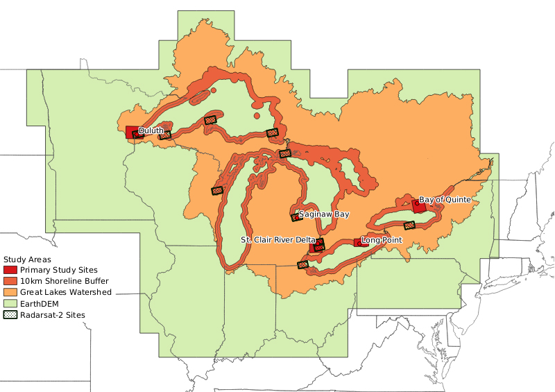
The near-term goal of the GLARS effort is to build an integrated, ongoing, remote sensing program for basin-wide mapping, monitoring, management and protection of Great Lakes coastal wetlands. The effort has initially focused on developing accurate elevation measurement of coastal wetland features and water level changes across time using two main data sources with frequent collection dates: submeter optical satellite imagery from the NextView program and RADARSAT-2 satellite imagery.
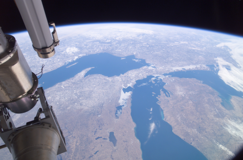
View of the upper Great Lakes taken from the International Space Station, April 1, 2004. Ice still present in Green Bay and other parts of the lakes. (NASA)
Building on established remote sensing methods to create high-resolution, multi-temporal products that will aid management efforts to protect coastal wetlands, this combination of optical and synthetic aperture radar (SAR) imagery is valuable to monitoring and/or mapping efforts such as:
- Wetland gain/loss
- Wetland types/extent (Optical and SAR)
- Invasive species change (Optical and SAR)
- Surface water extent (SAR)
- Inundation extent (SAR)
- Water level changes (InSAR)
- Canopy height changes via derived Digital Elevation Models (Optical)
- Habitat assessment
- Updates to the National Wetland Inventory
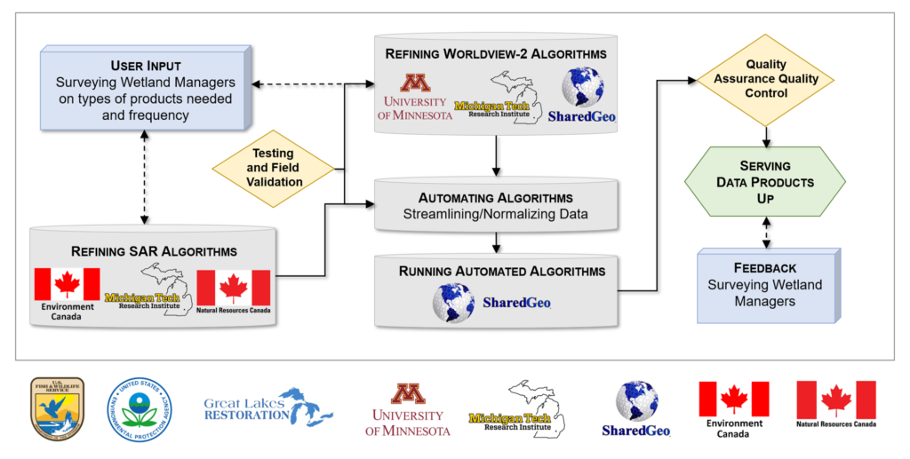
Project partners SharedGeo, RSGAL and MTRI have developed proof-of-concept techniques to provide these management products using a number of well-known pilot sites, and MTRI serves as the primary entity for validating the techniques through field testing. These techniques have been further developed by SharedGeo and RSGAL in conjunction with MTRI so that they have been or can be scaled up to basin-wide use and handle large frequently-changing imagery data sets, and support delivery systems to get up-to-date GLARS information to end users.
Project Collaboration and Work Flow
Great Lakes Restoration Initiative
Funding for GLARS provided by the congressionally mandated Great Lakes Restoration Initiative (GLRI):
GLARS Management
The following organizations significantly contributed to the development of GLARS through GLRI financial grants and management support:
GLARS Founding Members

Canadian Partners
Collaborators
- Minnesota Department of Natural Resources – Resource Assessment
- National Center for Supercomputer Applications – University of Illinois (Blue Waters Supercomputer)
- National Geospatial-Intelligence Agency
- National Oceanic Atmospheric Administration
- National Science Foundation – Great Lakes Consortium for Petascale Computing
- The Ohio State University
Get Started
In much the same way a road trip needs a map to visualize and manage travel, Great Lakes Alliance for Remote Sensing (GLARS) partners have been developing remote sensing products and approaches which other GLRI projects can use to visualize environmental issues and manage remediation by location. The other pages of this site provide expanded information about GLARS member efforts, as well as how to obtain resulting products.
Project
Find here information on the Great Lakes and how GLARS team members have been working to create an active, ongoing, remote sensing infrastructure for the basin.
Data
Find here information on the currently available GLARS remote sensing data and how to download for free.